
Table of Contents
System Architecture
This document provides an overview of all the elements that are required to operate the addressing system data infrastructure.
1. Scope of the Specification
The scope of this document encompasses the essential requirements for the creation, maintenance, and dissemination of addresses within the National Addressing System project in Oman. It provides a detailed exploration of the necessary components and methodologies for effective addressing.
To create and maintain addresses, several critical elements are required. Infrastructure forms the foundational backbone, ensuring a robust system framework to support operations. Reliable storage solutions are vital for the systematic archiving and retrieval of address data. Application Programming Interfaces (APIs) play a crucial role, facilitating seamless communication between different software components involved in processing and managing addresses. Furthermore, dedicated applications are necessary to ensure user-friendly interaction and efficient management of the addressing system.
In making addresses available to third parties, the establishment of appropriate frameworks and protocols is crucial. This involves the development of APIs designed to enable external entities to access and utilise address data efficiently. Additionally, licensing arrangements must be in place to manage the legal and commercial aspects of data sharing, ensuring compliance with regulatory standards and safeguarding data privacy.
Integration of addresses into other systems demands formulated strategies or 'recipes' that outline the steps and methodologies required for seamless incorporation. This integration supports functionality across varied systems, ensuring that address data enhances broader operational processes.
High-value integrations with government and private sector entities are proposed. Such integrations would allow for improved service delivery in the public sector, such as in emergency response and utility management. In the private sector, it could enhance commercial operations, logistics, and customer service practices by providing accurate and reliable address information. These partnerships are vital for maximizing the benefits of the National Addressing System, promoting efficiency, and facilitating economic and infrastructural development.
3. Systems Needed to Manage and Use NAS Data
To deliver a reliable and scalable National Addressing System (NAS), it is essential to implement a structured technical architecture that supports the full lifecycle of address data, from creation to integration and public use. This chapter outlines the key system components required to manage and utilize NAS data effectively, ensuring high data quality, interoperability, and accessibility.
The chapter is structured into five interdependent layers, as illustrated in the system architecture diagram (see illustration on the next page):
- Data Model: Defines the logical and relational structure of address data, including production, foundational, and distribution layers, as well as supporting basemap and imagery datasets.
- Data Layer: Specifies the database systems used to store and manage address data, including considerations for compatibility, performance, spatial features, and licensing.
- API Layer: Describes the web services and interfaces that allow external systems to retrieve, update, and validate address data securely and efficiently.
- Application Layer: Introduces the suite of tools, web, desktop, and mobile, designed to support address data creation, maintenance, validation, and signage management.
- Infrastructure Layer: Covers the underlying hardware, network, and security requirements to ensure continuous, secure, and high-performance system operations.
Together, these components form a comprehensive technology stack that supports both internal workflows and external integrations. Each section below expands on the role, design, and implementation considerations of the respective layer in the overall NAS ecosystem.

4. System architecture overview diagram
The business of street addressing is a complex set of interrelated managerial, planning, technical and engineering/civil works tasks that involves a broad range of distinctive end-users. The diagram below provides an overview of all the components that are required for the efficient operation and flow of data in the addressing system.
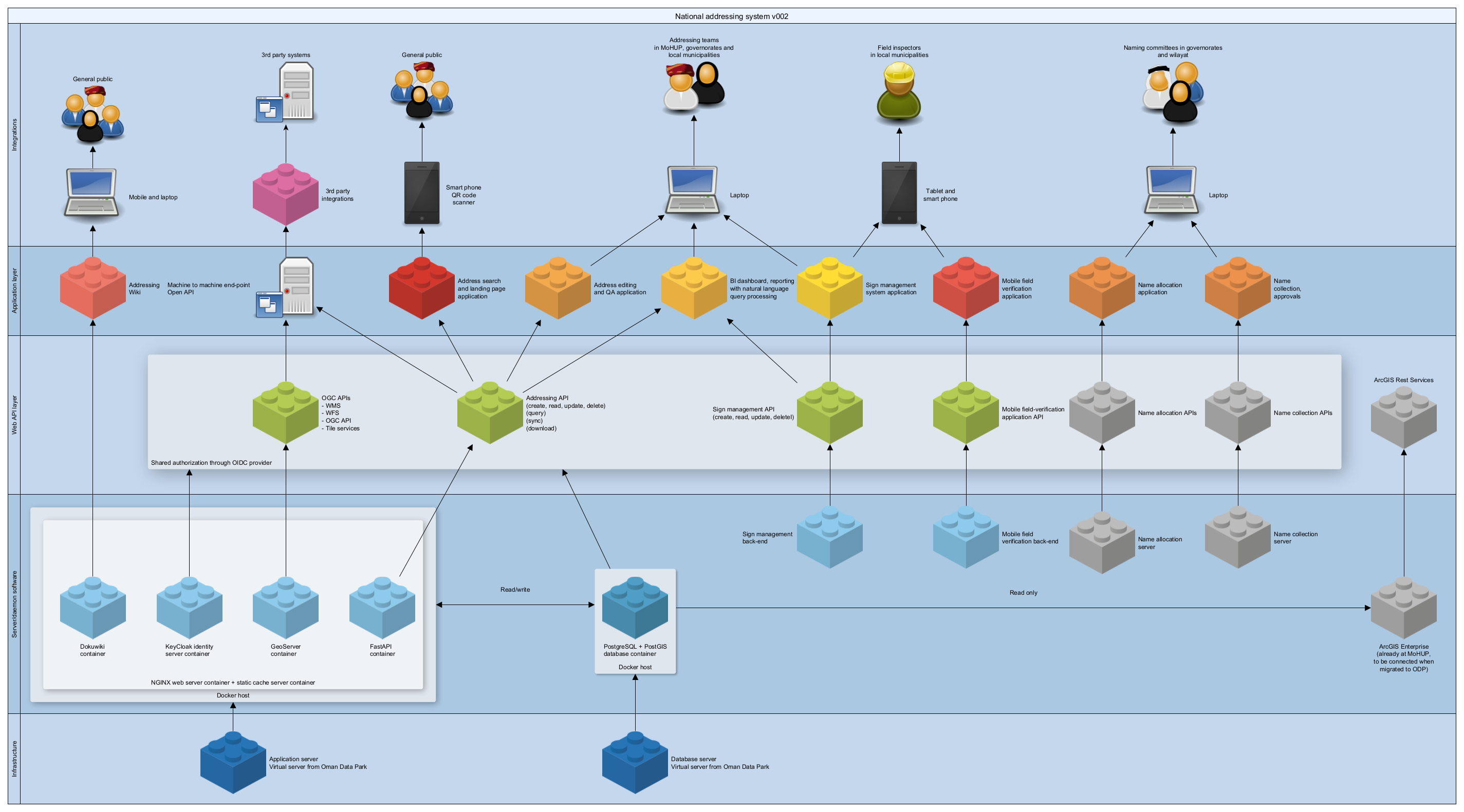
The diagram can be read both bottom up and top down. From the point of view of technical resources, the preferred reading direction is bottom up, for people who find themselves in end-user roles, it is more easily read from top to bottom.
5. Data models
This section describes which data should be created and maintained in the addressing system.
5.1 Addressing data model
The National Addressing System in Oman requires a robust data model to efficiently store, maintain, query, and retrieve address information. This system is structured into several parts, each with distinct roles and data tables to facilitate various address-related operations.
- Documentation for the addressing data model
5.2 Sign management data model
- Documentation for the sign management data model (to be supplied by future appointed vendor)
5.3 Name collection data model
- Documentation for the naming data model (to be supplied by existing vendor)
5.4 Name allocation data model
- Documentation for the naming data model (to be supplied by existing vendor)
5.5 Field verification application data model
- Documentation for the naming data model (to be supplied by existing vendor)
6. Data Layer
Once we have established a functional data model, it is necessary to acquire and configure a suitable database for implementation so that we have somewhere to store our data. Selecting an appropriate database platform requires careful evaluation of several key factors.
Compatibility
Compatibility is crucial, including integration with existing infrastructure, operating systems, other databases, and the current skill set of the team. The database should be manageable and align with the existing environment to ensure seamless operations.
Capacity
The database must handle concurrency and large volumes of data efficiently. This ensures that multiple users can access and manage data concurrently without degradation in performance.
Features
Key features such as spatial data support, JSON support, and Object-Relational Mapping (ORM) capabilities should be present. These features facilitate advanced data handling and interoperability with other systems.
Performance and pricing
Performance is an important aspect, focusing on uptime and query speed. Additionally, pricing and licensing are significant factors. Evaluating existing agreements with database vendors, such as SQL Server, can influence the cost-effectiveness of the solution. Open-Source options like PostgreSQL offer a no-cost alternative and are widely used by major institutions, such as Deutsche Bank.
Interfaces and services
The ability of the database to integrate with Geographic Information System (GIS) platforms is important, particularly through interfaces like ArcGIS and compliance with the Simple Features Specification. Additionally, the provision of REST APIs is essential for external integrations.
Selected database platform
Initially, the project selects Oracle as the database platform. This decision is due to legacy considerations, compatibility with existing infrastructure, and the integration capabilities with the ArcGIS Enterprise GIS platform. Oracle is known for its robustness, extensive features, and reliability.
Potential for value engineering
For future value-engineering purposes, SQL Server and PostgreSQL warrant consideration. Both offer features that match Oracle's capabilities for the National Addressing System. For integration purposes, solutions like an RDF/RDFA/RDFS quad store, such as OpenLink Virtuoso, might be explored to improve data interconnectivity and usability.
7. API layer
The Application Programming Interface (API) layer serves as a conduit for data exchange with the database. It facilitates data retrieval and submission, ensuring seamless interaction with stored information.
All applications provided by the NAS eco-system of software applications and services must be accessible through a shared user account.
- Address Integration API (vendor to be appointed by by competitive tender)
- Naming API (to be supplied by existing vendor)
- Signage API (vendor to be appointed by by competitive tender)
8. Application layer
Below, you will find technical and functional requirements for the following applications
9. Infrastructure layer
The database and applications must be run from some server infrastructure. It is assumed that the system at most may have some 120 concurrent users working in 63 different wilayat, municipalities, governorate offices as well as centrally at Ministry of Housing and Urban Planning.
On top of that, there may be 1000s of users accessing the data retrieval and query interfaces in the API. The following hardware and networking infrastructure requirements are based on the above assumptions.
10. Emerging technologies and future proofing
To ensure the National Addressing System (NAS) remains adaptable, sustainable, and aligned with technological advancements, continuous observation and selective adoption of emerging technologies are essential. The following areas are identified as particularly relevant for supporting NAS objectives now and in the future:
Geospatial Artificial Intelligence (GeoAI)
AI and machine learning, especially in geospatial domains, can greatly enhance the system’s ability to detect changes in urban and rural landscapes, automate address updates, and improve data quality through predictive analytics. Early exploration of GeoAI tools—for example, those capable of identifying new constructions, road networks, or informal settlements from satellite imagery—will position the NAS for smarter, automated data management and urban planning insights.
Internet of Things (IoT) and Smart Signage
Integrating IoT technologies such as sensor-equipped or connected street and building signage will allow real-time monitoring of asset status, automate maintenance alerts, and support enhanced data collection in the field. Smart signage, with QR codes or NFC tags linked directly to the NAS database, will provide end users, field staff, and emergency services with instant, up-to-date location information via mobile devices.
Cloud-Native Platforms and Scalability
Cloud infrastructure and platform-as-a-service offerings should be continuously evaluated to leverage advances in elasticity, automated scaling, and distributed processing. Serverless computing, event-driven architectures, and managed geospatial services can offer both cost efficiencies and operational flexibility as usage patterns evolve.
Open Data and API Ecosystem
Maintaining compatibility with emerging API standards and open data initiatives will ensure broad accessibility, support external innovation, and facilitate cross-sector integration. Observing trends such as OGC API standards, RESTful best practices, and new authentication protocols is recommended.
Mobile and Edge Computing
Advances in mobile platforms, including edge computing capabilities, will further enable offline-first workflows, low-latency processing in the field, and robust support for remote and bandwidth-constrained environments.
Sustainability and Green IT
Monitoring trends in sustainable IT—such as energy-efficient data centres, carbon footprint tracking, and low-power IoT deployments—will contribute to the long-term viability and environmental responsibility of the NAS infrastructure.
Technology road map
It is recommended to establish a technology roadmap and review process, ensuring that the NAS project routinely evaluates relevant innovations for potential adoption. This forward-looking posture will help maintain the system’s value and resilience as technology landscapes evolve.
12. Making Addressing Data Available to Users
The availability of addressing data through diverse platforms is a critical initiative aimed at enhancing data accessibility and usability. Facilitating this, NAS data will be made available through well-known map applications such as Google Maps and Apple Maps, thereby reaching a broad spectrum of users.
Additionally, collaborations with prominent automotive and business data providers, such as Navteq and Teleatlas, are set to further disseminate addressing data into a wide range of contexts where they may add value. To cater to technical audiences, a Python library will be developed, enabling programmers and data analysts to interact efficiently with the Open API endpoints. Moreover, a straightforward web-based address search application will be introduced, broadening access to basic address information for all users.
12.1 Via well-known map apps
NAS data will be integrated with popular mapping services to ensure extensive reach. Through Google Maps, NAS data will be accessible to Android users and those utilising Android Auto in vehicles. Similarly, Apple Maps will provide access to NAS data for iPhone users and those using CarPlay. This integration aims to offer comprehensive addressing information directly within platforms that users are already familiar with.
12.2 Via well known automotive and business data providers
Integrating NAS data into systems provided by leading automotive and business data companies such as Microsoft Here (formerly Navteq) and Tom Tom (also incorporating the former Teleatlas) will enhance its reach in the navigation domain. These partnerships will facilitate the use of NAS data in in-car navigation systems via Microsoft and other providers. Users will benefit from enhanced search and navigation capabilities. Secure methods, including external authentication and self-registration, will be employed.
Pathways to regular integration:
- Google: Authoritative partnerships via Google's Geo Data Upload Portal (by invitation or request).
- Apple: Apple accepts data from trusted partners, governments, and organizations through the Apple Maps Public Partner Portal. It is possible to become a Data Partner to contribute verified address, POI, and road data.
- Here: HERE actively works with local governments, data providers, and partners via its Map Creator Community and formal Data Partnership Program
- TomTom: TomTom accepts contributions from public and commercial entities through the TomTom Map Input Tool and TomTom Partner Programs. TomTom also has a structured process for government/agency partners.
Further details on how to get started with integrations can be found on the linked resource
12.3 Catering to programmers and data analysts
A dedicated Python library will be developed to streamline interaction with the Open API. This will allow data analysts and programmers to efficiently work with NAS data. Consideration will also be given to the development of libraries in other programming languages, aiming to broaden accessibility and usability for various technical audiences.
12.4 Providing a basic address search application for all
An official web-based application will be introduced to offer a simple and user-friendly address search tool. This application will enable easy access to basic address data for a wide range of users, regardless of technical expertise. This initiative aims to make fundamental address search functionalities readily available to the public.
13. Third party integrations
— Putting addressing to Work for Oman
Integration refers to the incorporation of addressing systems into various operational, security, and convenience-oriented applications for both residents and visitors in the Sultanate of Oman. It involves embedding addressing as an element within a database table or an object model in business applications. This enables effective indexing and geocoding of records and subsequent location of assets and/or delivery locations for goods services and people.
13.1 The Purpose of Integrating Addressing into other systems
The integration of addresses into other systems serves several essential purposes, primarily aimed at creating value for individuals, businesses, organisations and government bodies. Address systems become meaningful only when they actively contribute to achieving specific objectives, thereby justifying the considerable effort and expense involved in their implementation.
The concept of “value” within the context of address integration encompasses several aspects. Firstly, it provides ease in locating items or places, making navigation and discovery more straightforward. It also contributes to speed by enabling the faster delivery of people, goods, and services. Moreover, it can reduce costs associated with tasks such as locating customers – or even absconding taxpayers. An integrated address system enhances safety by minimising risks during emergency situations, such as reducing the likelihood of injury due to timely assistance.
In addition to tangible measures, the notion of an improved addressing system further extends to being just, fair, and equitable, providing benefits across various sectors. The system should also be accessible, facilitating easier operations, and its visual presentation should be designed for aesthetic appeal, or at the very least not to scare off users.
To illustrate the value added by integrated address systems, consider several examples. They allow for precise specification of delivery locations, ensuring parcels reach their intended destinations efficiently. The system also aids in identifying the location of individuals or entities, such as querying the whereabouts of “Krookie XYZ”. Furthermore, during urgent scenarios, such as calling for an ambulance, verbal communication of locations becomes clearer and more reliable.
Additionally, integrated address systems enable users to conveniently identify and associate multiple personal assets with specific locations. This includes one's land, house, telecom subscriptions, electricity meters, vehicles, and other property. An address acts as an efficient key that links and organises various belongings, simplifying management and oversight. For a person wishing to access a public service, it is necessary to identify him or herself by some means known to both parties. Successful and widespread adoption of addresses will often make it possible to identify the objects or assets under discussion out of hand.
13.2 How integrations will be done
Integration processes will be executed by business owners, not by the Ministry of Housing, Urban Planning. MoHUP will support by providing data access, adapting services, and facilitating systems. While MoHUP may promote integration and encourage business owners to recognise its benefits, ultimate responsibility rests on the business owners. Given the sensitivity of critical systems, business owners must perceive the value of integration for it to proceed independently.
Many business systems are already structured to accommodate addressing, particularly the newly implemented international formats. MoHUP's primary responsibility will be to ensure stakeholders are informed about, and have access to, necessary data and systems, thereby enabling seamless integration.
13.3 Proposed integrations
14. Data Quality Framework
High-quality address data is fundamental to the effectiveness, reliability, and public trust in the NAS. A robust data quality framework is therefore required, spanning initial collection, ongoing maintenance, and all migration processes. Data quality is the matter for other deliverables in this project, but a brief outline of key elements of the framework is cited below.
15. Transitional Arrangements
In the development and implementation of the National Addressing System (NAS) in Oman, transitional arrangements must be undertaken to create and maintain NAS data effectively. Both scenarios, where no existing system is present and where an existing system is in place, need specific approaches to ensure a smooth transition.
16. Cost Calculations
17. References
This document is in large part based on and supercedes the deliverable designated “D5” from the 2024/25 National Addressing System project carried out by NorthSys as consultant to the Ministry of Housing and Urban Planning.
The following references are provided as information sources on deliverables related to system implementation and integration in both the Unified Addressing System (UAS) Project and the current National Addressing System (NAS) Project.
References Unified Addressing System (UAS) Project:
- D1.1 Assessment report and recommendations for system enhancements v009
- D1.2 Addressing system redesign, logical and physical data model v023
- D1.3 Technical specification for addressing data population v014
- D2.2 Technical Specification for Infrastructure v003
- D2.3 System architecture design document v003
- D2.5 Addressing data framework and inter-system synchronization process v003
- D3.2 Integration framework with detailed report on data, business and process v001
References National Addressing System (NAS) Project:
- D3 - Operational training manual - ver. 2.0, including Annex A - The Addressing Standard ver. 2.0
- D5 - System implementation -and integration plan (this document)
- D8 - Data capturing training manual ver. 2.0, including Annex A - The Data Creation Manual ver. 2.0, Annex B - Addressing data QA&QC ver. 2.0, and Annex C - Catalogue of Building Interpretation Samples ver. 2.0